by Craig Brelsford
Founder, shanghaibirding.com
INTRODUCTION
This post contains a list of the major places our team visited during the summer-long expedition. Scroll down for links to our eBird lists and for our bibliography.
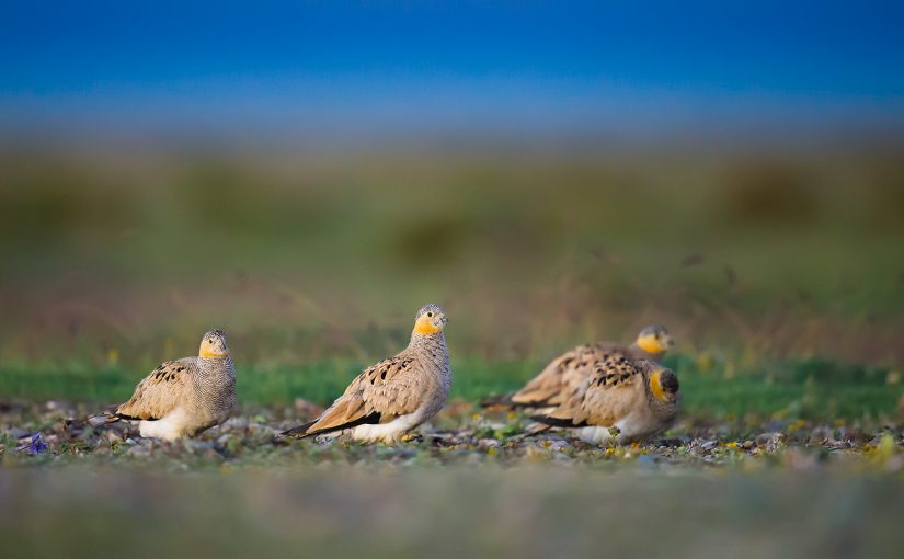
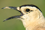
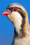
One of our most memorable ticks during our summer in Qinghai was Tibetan Sandgrouse (above), found at Hala Lake (38.205028, 97.520028) on 10 Aug.
LIST OF PLACE NAMES
— Many places in Qinghai have Tibetan or Mongolian names. For simplicity I have written place names only in English, simplified Chinese, and Pinyin.
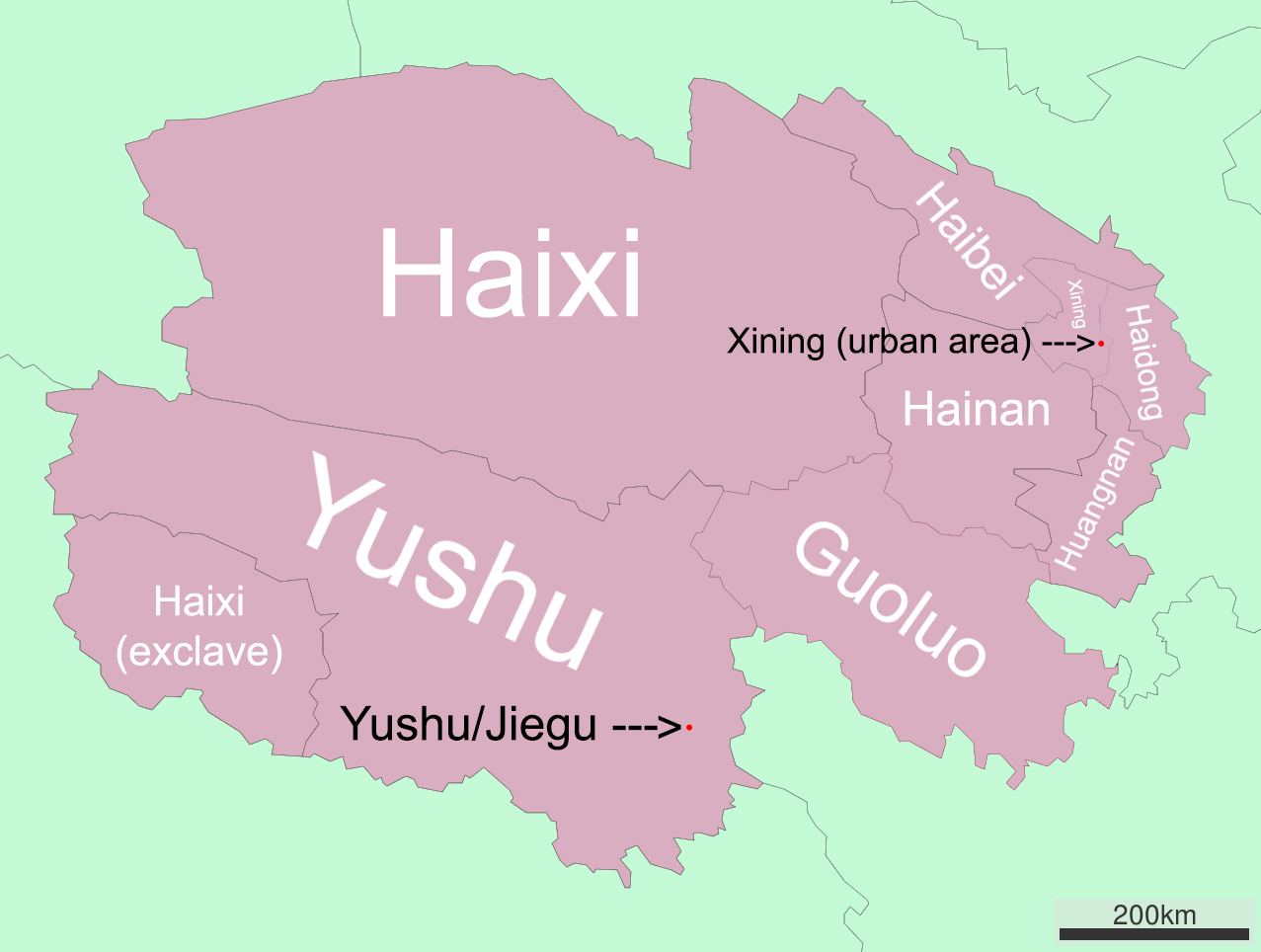
— In the system used here, in English all eight jurisdictions in Qinghai immediately below the provincial level are called “prefectures” (州), even though in two cases (Haidong and Xining) the word 市 (“city”) is used to designate the administrative area. Likewise, all jurisdictions immediately below the prefectural level are called “counties” (县), even though in some cases 市 is used to designate those administrative areas.
Alake Lake: see Lake Alake.
Babao River (Bābǎo Hé [八宝河]): tributary of Heihe River. Confluence at Qinghai-Gansu border in Qilian County.
Babao Zhen (Bābǎo Zhèn [八宝镇]): see Qilian Xiancheng.
Baizha Nature Reserve (Báizhā Sēnlín Zìrán Bǎohùqū [白扎森林自然保护区]): protected area Nangqian County, Yushu Prefecture. Junction of G214 & X832 at 31.966314, 96.535097. On some maps, X832 is called “Ranniang Section” (Ránniáng Duàn [然娘段]). This is the road that leads toward the nature reserve. At another turnoff (31.964250, 96.573340), bear right, leaving Ranniang Section, & continue on to the reserve. Gate at 31.882305, 96.556738. Elev. at gate is 3910 m (12,840 ft.).
Banjie Gou (Bànjié Gōu [半截沟]): village Menyuan County, Haibei Prefecture. 37.681962, 101.240959.
Bayankala Pass (Bāyánkālā Shānkǒu [巴颜喀拉山口]): pass on G214 near Qinghai-Sichuan border. Elev.: 4824 m (15,823 ft.). 34.114476, 97.661992.
Chacha Cun (Cháchá Cūn [查查村]): village Dulan County. 36.674281, 98.133550.
Chaka (Chákǎ Zhèn [茶卡镇]): town & tourist center Wulan County, Haixi Prefecture. 36.791576, 99.078878.
Chaka Salt Lake (Chákǎ Yánhú [茶卡盐湖]). 36.702074, 99.112364.
Chenduo County (Chènduō Xiàn [称多县]): sub-prefectural administrative area Yushu Prefecture.
Chengdong District (Chéngdōng Qū [城东区]): district Xining Prefecture. Along with other nearby urbanized districts, commonly referred to as Xining. See also Chengxi District, Chengzhong District.
Chengxi District (Chéngxī Qū [城西区]): district Xining Prefecture. Along with other nearby urbanized districts, commonly refereed to as Xining. See also Chengdong District, Chengzhong District.
Chengzhong District (Chéngzhōng Qū [城中区]): district Xining Prefecture & heart of Xining conurbation. This district & three adjacent districts are commonly referred to as Xining. See also Chengdong District, Chengxi District.
Dagela Pass (Dàgélā Shān [大格拉山]): ridge dividing Yangtze & Mekong river systems in Yushu Prefecture. Reachable via X308. Elev.: 4752 m (15,587 ft.). 32.514573, 97.209993.
Dashui Qiao (Dàshuǐ Qiáo [大水桥]): village Gonghe County between Chaka & Heimahe. 36.691347, 99.457542.
Dashui Reservoir (Dàshuǐ Shuǐkù [大水水库]): dam & artificial lake near Dashui Qiao. 36.716292, 99.471655.
Datong River (Dàtōng Hé [大通河]): river N Qinghai & W Gansu. Tributary of Huangshui River. Part of Yellow River system.
Delingha County (Délìnghā Shì [德令哈市]) sub-prefectural administrative area Haixi Prefecture. Prefectural seat of Haixi Prefecture. Officially, Delingha “City.”
Dipanzi Village (Dìpánzi Cūn [地盘子村]): settlement Qilian County, Haibei Prefecture. Riparian forest of Small-leaf Poplar is across Heihe River at 38.212130, 100.160214.
Donggeicuona Lake: see Lake Donggeicuona.
Dongguan Mosque (Xīníng Shì Dōngguān Qīngzhēn Dàsì [西宁市东关清真大寺]): largest mosque in Qinghai. Built 1380. Located in Chengdong District, Xining. 36.615301, 101.797987.
Dulan County (Dūlán Xiàn [都兰县]): sub-prefectural administrative area Haixi Prefecture.
Dunhuang (Dūnhuáng Shì [敦煌市]): sub-prefectural administrative area W Gansu.
Ela Pass (Èlā Shānkǒu [鄂拉山口]): elev. 4499 m (14,757 ft.). 35.497608, 99.511449.
Eling Lake (Èlíng Hú [鄂陵湖]). One of the sources of Yellow River, in Maduo County, Guoluo Prefecture. Also known as Ngoring Lake. 34.902685, 97.709949.
Ga’er Monastery (Gǎěr Sì [尕尔寺]): Buddhist institution of worship in Nangqian County, Yushu Prefecture. 31.829966, 96.487758.
Gahai Lake (Gǎ Hǎi [尕海]): freshwater lake Delingha County, Haixi Prefecture. Elev.: 2850 m (9,350 ft.). 37.128349, 97.551656.
Galaga Pass (Gǎlāgǎ Yākǒu [尕拉尕垭口]): Elev.: 4493 m (14,737 ft.).
Gangze Wujie (Gǎngzé Wújié [岗则吾结]): peak South Shule Mountains, Tianjun County, Haixi Prefecture, Qinghai. At 5808 masl (19,050 ft.) highest peak in South Shule Mountains & Qilian Mountains. On some maps called Tuanjie Feng (Tuánjié Fēng [团结峰]). 38.503719, 97.718419.
Gansu (Gānsù Shěng [甘肃省]): province NW China bordering Qinghai to N & E. Area: 425,800 sq. km (164,400 sq. mi.).
Gonghe: word that can be used for Gonghe County & especially for Qiabuqia.
Gonghe County (Gònghé Xiàn [共和县]): sub-prefectural administrative area Hainan Prefecture.
Gouhua (Gōuhuā [沟花]): valley ca. 30 km W of Huashixia in Dulan County, Haixi Prefecture. Elev.: 3990 m (13,090 ft.). 35.363268, 98.655776.
Guoluo Prefecture (Guǒluò Zàngzú Zìzhìzhōu [果洛藏族自治州]): sub-provincial administrative area SE Qinghai. Area: 76,312 sq. km (29,464 sq. mi.). Full name: Guoluo Tibetan Autonomous Prefecture. Guoluo sometimes spelled “Golog.”
Greater Wild Horse Ridge (Dà Yěmǎ Lǐng [大野马岭]): mtn. Maduo County. Elev.: 4326 m (14,189 ft.). 34.658282, 98.228252.
Gyêgu: see Jiegu.
Haibei Prefecture (Hǎiběi Zàngzú Zìzhì Zhōu [海北藏族自治州]): sub-provincial administrative area NE Qinghai. Area: 39,354 sq. km (15,195 sq. mi.). Full name: Haibei Tibetan Autonomous Prefecture.
Haidong Prefecture (Hǎidōng Shì [海东市]): sub-provincial administrative area E Qinghai. Area: 12,810 sq. km (4,950 sq. mi.). Officially a “(prefectural-level) city.”
Hainan Prefecture (Hǎinán Zàngzú Zìzhìzhōu [海南藏族自治州]): sub-provincial administrative area E Qinghai. Area: 45,895 sq. km (17,720 sq. mi.). Full name: Hainan Tibetan Autonomous Prefecture.
Haixi Prefecture (Hǎixī Měnggǔzú Zàngzú Zìzhì Zhōu [海西蒙古族藏族自治州]): sub-provincial administrative area occupying all of NW & NC Qinghai & a portion of SW Qinghai. Area: 325,785 sq. km (125,786 sq. mi.). Area (comparative): slightly smaller than Norway; slightly larger than New Mexico. Largest prefecture in Qinghai. Pop.: 490,000. Prefectural seat: Delingha. Full name: Haixi Mongol and Tibetan Autonomous Prefecture.
Hala Lake (Hālā Hú [哈拉湖]): inland sea N Qinghai in Haixi Prefecture. Second-largest lake in Qinghai. Area: 607 sq. km (234 sq. mi.). Elevation: 4077 m (13,373 ft.). 38.267875, 97.575430.
Hedong (Hédōng [河东]): administrative area Delingha County. Seat of Haixi Prefecture & Delingha County. Along with Hexi forms urbanized area of Delingha County, & the two areas are most commonly referred to as “Delingha.”
Heihe River (Hēi Hé [黑河]): river NW China rising on N side of Qilian Mountains in Gansu, flowing through Haibei Prefecture in Qinghai, & returning to Gansu, where it runs through Hexi Corridor before drying up in Gobi Desert in W Inner Mongolia. Length: 630 km (391 mi.). Lower reaches known as Ruo Shui (Ruò Shuǐ [弱水]).
Heihe Xiang (Hēihé Xiāng [黑河乡]): village Maduo County. 34.600899, 98.268220.
Heimahe (Hēimǎhé Xiāng [黑马河乡]): village SW shore of Qinghai Lake in Gonghe County. Tourism center. 36.729239, 99.779524.
Hexi (Héxī [河西]): administrative area Delingha County. Along with Hedong forms urbanized area of Delingha County, & the two areas are most commonly referred to as “Delingha.”
Hexi Corridor (Héxī Zǒuláng [河西走廊]): historical trading route Gansu. Bordered S by Qilian Mtns. & Tibetan Plateau & N by Gobi Desert.
Himalayan Plateau: see Tibetan Plateau.
Huang He Xiang (Huáng Hé Xiāng [黄河乡]): village Maduo County. 34.600672, 98.268468.
Huangshui River (Huángshuǐ Hé [湟水河]): largest tributary of Yellow River. Runs through Xining.
Huashixia (Huāshíxiá [花石峡]): village Maduo County on G214. 35.101275, 98.860780.
Huzhu County (Hùzhù Tǔzú Zìzhìxiàn [互助土族自治县]): sub-prefectural administrative area Haidong Prefecture. Full name: Huzhu Tu Autonomous County.
Jiabo Hot Spring (Jiǎbō Wēnquán [甲波温泉]): thermal spring Qilian County on S204. Elev. 3790 m (12,430 ft.). 38.790355, 98.665485.
Jiading (Jiādìng Zhèn [加定镇]): tourist center Huzhu County on Datong River & Qinghai-Gansu border. 36.951698, 102.494353.
Jiangxi Huimu Vocational Training School (Yùshù Shì Jiāngxī Huìmù Zhíyè Péixùn Xuéxiào [玉树市江西惠牧职业培训学校]): institution specializing in teaching Buddhist-style painting. Near Jiangxi Forest Management Area in Nangqian County. Elev. 3600 m (11,810 ft.). 32.076395, 97.063995.
Jiangxi Forest Management Area (Jiāngxī Línchǎng [江西林场]): forestry center & series of villages (“Jiangxi Village”), Nangqian County. 32.076777, 97.009417.
Jiegu (Jiégǔ Zhèn [结古镇]): urbanized area Yushu County, seat of Yushu County & Yushu Prefecture. Pop.: 56,800. Elev.: 3700 m (12,140 ft.). Commonly referred to as Yushu. 33.002242, 96.978488.
Jinzi Lake (Jīnzi Hǎi [金子海]): freshwater lake Wulan County, Haixi Prefecture. Elev.: 2990 m (9,810 ft.). 36.719109, 97.886371.
Kanda Gorge: see Kanda Mountains.
Kanda Mountains (Kǎndá Shān [坎达山]): high country Nangqian County. Elev. at mouth of Kanda Gorge, near Mekong/Zaqu River (32.277059, 96.485171): 3670 m (12,040 ft.). Elev. Kanda Pass (32.314561, 96.624807): 4680 m (15,350 ft.). Junction of G214 & road leading to Kanda Mountains: 32.315911, 96.454165.
Kanda Nunnery: religious institution Kanda Gorge. Reliable site for Tibetan Partridge & Tibetan Babax. Elev.: 3910 m (12,830 ft.). 32.291641, 96.512173.
Kanda Pass: see Kanda Mountains.
Lake Alake (Ālākè Hú [阿拉克湖]): lake Dulan County, Haixi Prefecture. Elev.: 4749 m (15,577 ft.). 35.568917, 97.128349.
Lake Donggeicuona (Dōnggěicuònà Hú [冬给错纳湖]): lake Maduo County, Guoluo Prefecture. Elev.: 3950 m (12,960 ft.). 35.290072, 98.537098.
Lake Xiligou (Xīlǐgōu Hú [希里沟湖]): saline lake Wulan County, Haixi Prefecture. Elev.: 2950 m (9,680 ft.). 36.838594, 98.462896.
Lamaozhi Siyuan (Lāmáozhì Sìyuàn [拉毛志寺院])
Lianhe Cun (Liánhé Cūn [联合村]): village Dulan County, Haixi Prefecture. 36.627763, 98.235107.
Machali (Mǎchálǐ Zhèn [玛查理镇]): town W Maduo County. Commonly referred to as Maduo. 34.911354, 98.211208.
Madoi County: see Maduo County.
Maduo (Mǎduō [玛多]): word that can be used for Maduo County & especially for Machali.
Maduo County (Mǎduō Xiàn [玛多县]): sub-prefectural administrative area W Guoluo Prefecture. Area: 25,000 sq. km (9,700 sq. mi.). Also known as Madoi County.
Maozhuang (Máozhuāng Xiāng [毛庄乡]): village Nangqian County. 32.266550, 96.824579.
Mekong River: seventh-longest river in Asia, 12th in world. Rises in Qinghai. Upper reaches also known as Zaqu River.
Menggu Bao (Měnggǔ Bāo [蒙古包]): “Menggu bao” means yurt, or circular tent in the style of the Mongolians. Here, the name refers to the area for tourists at the northernmost point on Delingha-Hala road on S shore of Hala Lake.
Menyuan County (Ményuán Huízú Zìzhìxiàn [门源回族自治县]): sub-prefectural administrative area Haibei Prefecture.
Mole Zhen (Mòlè Zhèn [默勒镇]): town Qilian County. 37.716626, 100.579661.
Nanchuan River (Nánchuān Hé [南川河]): tributary of Huangshui River, which it meets in Xining.
Nangqên County: see Nangqian County.
Nangqian (Nángqiān [囊谦]): word that can be used for Nangqian County & especially for Xiangda.
Nangqian County (Nángqiān Xiàn [囊谦县]): sub-prefectural administrative area Yushu Prefecture. Area: 11,539 sq. km (4,455 sq. mi.). Pop: 57,000. Contains southernmost point in Qinghai & borders Tibet. Once semi-independent kingdom. Also known as Nangqên County.
Nanshan: see Qilian Mountains.
Ngoring Lake: see Eling Lake.
Przevalski’s Site: birding area Dulan Mountains, Dulan County, Haixi Prefecture. So called because Przevalski’s Partridge & Przevalski’s Redstart have been found there. Turnoff to birding area is at KM 2335.5 on G109. Birding area at 36.457249, 98.502578.
Qabqa: see Qiabuqia.
Qiabuqia (Qiàbǔqià Zhèn [恰卜恰镇]): urbanized area Gonghe County, seat of Gonghe County & Hainan Prefecture. Commonly referred to as Gonghe. 36.275266, 100.624701.
Qilian County (Qílián Xiàn [祁连县]): sub-prefectural administrative area Haibei Prefecture. Area: 15,610 sq. km (6,027 sq. mi.).
Qilian Mountains (Qílián Shān [祁连山]): range N China forming part of border between Qinghai & Gansu. Because range forms S boundary of Hexi Corridor, also known as Southern Mountains, or Nanshan (Nánshān [南山]).
Qilian Xiancheng (Qílián Xiànchéng [祁连县城]): informal & more commonly used name for Babao Zhen, administrative center of Qilian County in Haibei Prefecture. 38.176712, 100.247371.
Qinghai (Qīnghǎi Shěng [青海省]): province NW China. Area: 720,000 sq. km (278,000 sq. mi.). Area (comparative): three times larger than United Kingdom; slightly larger than Texas. Pop.: 5.6 million.
Qinghai Lake (Qīnghǎi Hú [青海湖]): largest lake in Qinghai. 36.877808, 100.228673.
Qinghai-Tibet Plateau: see Tibetan Plateau.
Qingshizui (Qīngshízuǐ Zhèn [青石嘴镇]): town Menyuan County, Haibei Prefecture. 37.474644, 101.397441.
Qingshuihe (Qīngshuǐhé [清水河]): town on G214 S of Bayankala Pass. Elev.: 4270 m (14,010 ft.). 33.804499, 97.141026.
Rubber Mountain Pass (Xiàngpí Shān [橡皮山]): mountain crossing 22 km (13.7 mi.) W of Heimahe on G109. Elev.: 3817 m (12,520 ft.). 36.754213, 99.606705.
Ruo Shui: see Heihe River.
Shule River (Shūlè Hé [疏勒河]): river NW China rising in Haibei Prefecture, Qinghai, flowing through W Gansu, & emptying (historically) in Lop Nur in Xinjiang. Length: 905 km (562 mi.). Also known as Changma River (Chāngmǎ Hé [昌马河]).
Sàrìlāmǎzhū (萨日拉玛珠)
Shanglaxiu (Shànglāxiù [上拉秀]): town Yushu County.
Sichuan (Sìchuān Shěng [四川省]): province SW China bordering Qinghai to SE. Area: 485,000 sq. km (187,400 sq. mi.).
South Shule Mountains (Shūlè Nánshān [疏勒南山]): sub-range of Qilian Mountains N of Hala Lake, Haixi Prefecture.
South Tuole Mountains (Tuōlè Nánshān [拖勒南山]): sub-range Qilian Mountains in N Qinghai & W Gansu. Range runs between Yanglong & Suli & forms part of border between Haibei & Haixi prefectures. On some maps, 拖勒 written 拖来.
Subei County (Sùběi Měnggǔzú Zìzhì Xiàn [肃北蒙古族自治县]): sub-prefectural administrative area W Gansu, bordering Qinghai.
Suli (Sūlǐ Xiāng [苏里乡]): village on Shule River in Tianjun County, Haixi Prefecture. 38.702633, 98.026018.
Tiegai Xiang (Tiěgài Xiāng [铁盖乡]): village Gonghe County, Hainan Prefecture. 35.989249, 100.194396.
Tianjun County (Tiānjùn Xiàn [天峻县]): sub-prefectural administrative area Haixi Prefecture.
Tibet (Xīzàng Zìzhìqū [西藏自治区]): provincial-level entity SW China bordering Qinghai to S. Area: 1,228,400 sq. km (474,300 sq. mi.). Full name: Tibet Autonomous Region.
Tibetan Plateau (Qīng Zàng Gāoyuán [青藏高原]): vast elevated plateau C Asia encompassing much of Qinghai. Highest & largest plateau on Earth. Contains headwaters of several major rivers, among them Yangtze River, Yellow River, & Mekong River. Chinese name translates as “Qinghai-Tibet Plateau.” Also known as Himalayan Plateau.
Tit-Warbler Mountain: birding spot near Heimahe containing much good scrub. To reach it, take the G109 from Heimahe to a dirt road near KM 2187 (36.782112, 99.675814). Drive to the end of this dirt road at 36.766994, 99.667711. Peak is at 36.758683, 99.663055. Elevation at top is 3620 m (11,870 ft.).
Tongtian River (Tōngtiān Hé [通天河]): another name for upper Yangtze River.
Tuanjie Feng (Tuánjié Fēng [团结峰]): see Gangze Wujie.
Tuole River ([拖勒河]): tributary of Heihe River. On some maps, 拖勒 written 拖来.
Ulan County: see Wulan County.
Wenquan (Wēnquán [温泉]): town Xinghai County, Hainan Prefecture.
Wulan County (Wūlán Xiàn [乌兰县]): sub-prefectural administrative area Haixi Prefecture. Also known as Ulan County. Area: 10,784 sq. km (4,164 sq. mi.)
Xiangda (Xiāngdá Zhèn [香达镇]): administrative center of Nangqian County. Commonly referred to as Nangqian. 32.202992, 96.475617.
Xiangride (Xiāngrìdé [香日德]): town Dulan County, Haixi Prefecture. 35.993651, 97.894235.
Xiangride River: watercourse Dulan County, Haixi Prefecture.
Xiao Sumang Xiang (Xiǎo Sūmǎng Xiāng [小苏莽乡]): village Yushu County near Qinghai-Tibet border. 32.347744, 97.252561.
Xinghai County (Xīnghǎi Xiàn [兴海县]): county SW Hainan Prefecture.
Xingxing Hai (Xīngxīng Hǎi [星星海]): lake Maduo County.
Xining (Xīníng [西宁]): word that can be used to refer to all of Xining Prefecture but most commonly used to describe the four urbanized districts centered around Chengzhong.
Xining Caojiabao Airport (Xīníng Cáojiābǎo Jīchǎng [西宁曹家堡机场]): airport Huzhu County, Haidong Prefecture, 30 km (19 mi.) E of downtown Xining. IATA: XNN. 36.527923, 102.040889.
Xining Prefecture (Xīníng Shì [西宁市]): sub-provincial administrative area NE Qinghai. Capital of Qinghai & most populous city on Tibetan Plateau. Area: 7372 sq. km (2,846 sq. mi.). Officially a “(prefectural-level) city.”
Yangkang Xiang (Yángkāng Xiāng [阳康乡]): village E of Hala Lake in Tianjun County, Haixi Prefecture. 37.675509, 98.635267.
Yanglong Xiang (Yānglóng Xiāng [央隆乡]): village W Haibei Prefecture, on the S204. 38.816483, 98.415873.
Yangtze River (Cháng Jiāng [长江]): longest river in Asia, third-longest in world. Rises in Qinghai.
Yankou Shan (Yànkǒu Shān [雁口山]): mtn. N of Yushu-Jiegu. Some slopes covered with primary high-alpine scrub. Elev.: 4458 m (14,622 ft.). 33.199406, 97.466606.
Yellow River (Huáng Hé [黄河]): third-longest river in Asia, sixth-longest in world. Rises in Qinghai.
Yeniu Gou (Yěniú Gōu [野牛沟]): village Qilian County. 38.457395, 99.542667.
Yong’an River (Yǒng’ān Hé [永安河]): river Haibei Prefecture.
Yushu Batang Airport (Yùshù Bātáng Jīchǎng [玉树巴塘机场]): airport Yushu Prefecture 18 km (11 mi.) S of Yushu-Jiegu. Elev. 3890 m (12,760 ft.). Eighth-highest civilian airport in world. 32.824982, 97.124989.
Yushu (Yùshù [玉树]): word that can be used to refer to Yushu Prefecture, to Yushu County, or most commonly to Jiegu.
Yushu County (Yùshù Shì [玉树市]): sub-prefectural administrative area Yushu Prefecture. County seat: Yushu-Jiegu. Area: 13,462 sq. km (5,198 sq. mi.). Pop.: 120,447. Officially, Yushu “City.”
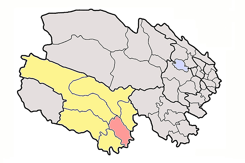
Yushu Prefecture (Yùshù Zàngzú Zìzhìzhōu [玉树藏族自治州]): sub-provincial administrative area Qinghai. Area: 188,794 sq. km (72,894 sq. mi.). Area (comparative): half the size of Germany; slightly larger than North Dakota. Second-largest prefecture in Qinghai. Covers most of S Qinghai. Pop.: 296,000. Prefectural seat: Yushu-Jiegu. Full name: Yushu Tibetan Autonomous Prefecture.
Zaqu River (Zāqū [扎曲]): name for upper reaches of Mekong River in Qinghai.
Zhalong Gou Scenic Area (Qīnghǎi Shěng Hùzhù Běishān Zhālóng Gōu Jǐngqū [青海省互助北山扎龙沟景区]): protected area Huzhu County, Haidong Prefecture. 36.792287, 102.460685.
Ziqu River (Ziqū [子曲]): tributary of Zaqu River. Flows through Nangqian County.
eBIRD LISTS
26 June Haidong
27 June Jiading
27 June Xiaobeihu Freshwater Marsh
28 June Heimahe
29 June Qinghai Lake–K11 hill
29 June Dashui Reservoir
30 June Rubber Mountain Pass
30 June Birding Areas W of Chaka
01 July Przevalski’s Site
02 July Scrub S of Gonghe-Qiabuqia
02 July E’La Mountain Pass
03 July Eling Lake
04 July Wetlands along G214 S of Maduo-Machali
04 July Bayankala Pass
04 July Yankoushan Scrub
04 July Yushu-Jiegu
05 July Yushu-Jiegu
05 July Kanda Mountain
06 July Baizha Forest Management Area
07 July Baizha Forest Management Area
08 July Baizha Forest Management Area
09 July Kanda Mountain
09 July Yushu-Jiegu
10 July Yushu-Jiegu
12 July Xiao Sumang Xiang
13 July Xiao Sumang Xiang
14 July Yushu-Jiegu
14 July Nangqian Area
15 July Nangqian Area
15 July Nangqian Area
16 July Nangqian Area
17 July Nangqian Area
17 July Yushu Area
18 July Yushu Area
19 July Maduo
20 July Maduo
21 July Elashankou 4499 m
21 July Dōnggěicuònà Hú
22 July Xiangride
22 July Przevalski’s Site
23 July Przevalski’s Site
23 July Birding Areas W of Chaka
24 July Chaka Marsh
24 July Dashui Reservoir
27 July Xining
30 July 227 National Road Menyuan
30 July S302 Panda Highway
31 July S302 Panda Highway
31 July S204 From Mole to Qilian
01 Aug. Conifer Forest S of Qilian
02 Aug. S204 From Mole to Qilian
02 Aug. Heihe River Poplar Forest
03 Aug. Heihe River Poplar Forest
04 Aug. Heihe River Poplar Forest
04 Aug. Qilian to Yeniugou
05 Aug. Qilian to Yeniugou
06 Aug. Yanglong
07 Aug. Suli
08 Aug. Hala Lake
09 Aug. Hala Lake
10 Aug. Hala Lake
11 Aug. Hala Lake
12 Aug. Hala Lake
13 Aug. Hala Lake
14 Aug. Hala Lake
14 Aug. Gahai Lake
16 Aug. Lake Xiligou
17 Aug. Backcountry SW of Wulan
18 Aug. Jinzi Lake
19 Aug. Birding Areas W of Chaka
19 Aug. Jinzi Lake
19 Aug. Przevalski’s Site
20 Aug. Dashui Reservoir
21 Aug. Scrub S of Gonghe-Qiabuqia
BIBLIOGRAPHY
Brazil, Mark. Birds of East Asia. Princeton University Press. Consulted in Shanghai.
del Hoyo, Josep, et al., eds. The Handbook of the Birds of the World. Lynx Edicions.
Grimmett, Richard, Carol Inskipp, and Tim Inskipp. Birds of the Indian Subcontinent. Christopher Helm. One of three field guides we had with us in Qinghai, the others being MacKinnon’s a Field Guide to the Birds of China and the Collins Bird Guide.
Kennerley, Peter & David Pearson. Reed and Bush Warblers. Christopher Helm. Consulted at home.
Lynx Edicions. The Internet Bird Collection. ibc.lynxeds.com
MacKinnon, John & Karen Phillipps. A Field Guide to the Birds of China. Oxford University Press. Along with the Collins Bird Guide and Birds of the Indian Subcontinent, one of the field guides we took with us to Qinghai.
Oriental Bird Club. Oriental Bird Images. orientalbirdimages.org
Smith, Andrew T. & Yan Xie, eds. Mammals of China. Princeton University Press.
Mullarney, Killian, Lars Svensson, Dan Zetterström, Peter Grant. Collins Bird Guide: The Most Complete Guide to the Birds of Britain and Europe. HarperCollins. Useful even in Qinghai. One of the three field guides we used in Qinghai.
Xeno-Canto Foundation. Xeno-Canto: Bird Sounds from Around the World. xeno-canto.org.
EQUIPMENT
Cameras: Nikon D3S; for landscapes, Apple iPad, Apple iPhone 4S, and Apple iPhone 6
Lens: Nikon VR 600mm F/4G
Sound recorder: Olympus DM-650
Binoculars: Swarovski EL 8 x 32 (Craig), Zeiss Conquest HD 8 x 42 (Elaine)
Spotting scope: Swarovski ATX-95
INDEX
shanghaibirding.com offers unparalleled coverage of birding in Qinghai. Below is an index to our posts on Qinghai. Reach us at info@shanghaibirding.com.
Summer-long Birding Expedition to Qinghai (Introduction): We birded Qinghai from June to August, spending the entire summer in the province. We noted classic Tibetan Plateau birds White Eared Pheasant, Black-necked Crane, White-browed Tit, and Przevalski’s Redstart. We explored little-birded northern Qinghai, discovering new locations for Przevalski’s Partridge, Tibetan Sandgrouse, and Gansu Leaf Warbler.
Birding Eastern Qinghai, from the Border with Gansu to the Border with Tibet: We spent the first two weeks of the expedition covering eastern Qinghai, from the Gansu border in northeast Qinghai to Ga’er Monastery on the border with Tibet. We had Henderson’s Ground Jay west of Chaka, Ibisbill on tributaries of the Mekong River, White-browed Tit in scrub along the G109, and Güldenstädt’s Redstart breeding near Qinghai Lake.
Birding Qinghai’s Eastern Yushu Prefecture: We found Tibetan Lynx in the Kanda Mountains, discovered new birding sites, and at an art school in the wilderness immersed ourselves in Tibetan Buddhist culture. Among our highlights were Grandala and Red-fronted Rosefinch, the highest-breeding bird in the Palearctic. Our mammals included White-lipped Deer and Mongolian Five-toed Jerboa, and we saw evidence of attacks by Brown Bear.
Birding the Qilian Mountains of Northern Qinghai: Our most important discovery was the poplar forests along the Heihe and Babao rivers, where we encountered woodland species Gansu Leaf Warbler and Chinese Thrush. Conifer forests yielded Black Woodpecker, and the scrub and pastureland gave us Eurasian Eagle-Owl, Siberian Roe Deer, and Mountain Weasel.
Forbidding (and Forbidden) Hala Lake: Defying a ban on foreigners, we birded the wild, remote inland sea in north-central Qinghai, elev. 4077 m (13,376 ft.). The lake yielded several interesting Qinghai records, among them Little Stint, Curlew Sandpiper, and Eurasian Whimbrel. Near shore, in perfect semi-desert habitat, we discovered flocks of Tibetan Sandgrouse.
Birding the Remote Backcountry of Wulan County, Qinghai: Amid stunning scenery, we found Tibetan Wolf, discovered a new location for Przevalski’s Partridge, and around Lake Xiligou had Qinghai favorites Black-necked Crane and Tibetan Lark. The lake held a noisy super-flock of 4,600 Ruddy Shelduck, and Mongolian Goitered Gazelle were in the hills behind. Near Chaka we had Mute Swan.
Index to Place Names in Qinghai (you are here)
Mammals and Birds of the Tibetan Plateau: Our team drove 3977 km (2,471 mi.) in 15 days, starting and ending in Golmud, Qinghai. In mountains as high as 5100 m (16,730 ft.), we found 98 species of bird. Mammals were the big stars. I watched a Tibetan Fox catch and devour a vole, we found 46 Tibetan Antelope and a Tibetan Wolf in Antelope Valley, and we saw dozens of Tibetan Wild Ass.
Tibetan Bunting Leads Parade of Tibetan Plateau Endemics in Qinghai: shanghaibirding.com founder Craig Brelsford led a three-person team on a 23-day trip to Qinghai. We covered most of the Tibetans (Tibetan Snowcock, Tibetan Partridge, Tibetan Babax, Tibetan Rosefinch, and Tibetan Bunting) and found Przevalski’s Finch near Qinghai Lake.
Qinghai in October: Jesper Hornskov and his team noted 178 species of bird in October, a time of year, Hornskov writes, “when few dedicated birdwatchers visit this unique land.”
Qinghai in the Age of Covid: Covid-19 complicated the trip, but watching Tibetan Wolf pups frolic made all the trouble worthwhile. We sampled a wide array of western China birds, among them Daurian Partridge, Pallas’s Sandgrouse, and White-winged Grosbeak.
In addition to coverage of Qinghai and our core area of Shanghai, shanghaibirding.com has extensive coverage of other areas of China, among them
Fujian
Northeast China
Sichuan
Xinjiang
Yunnan